DePIN is driving blockchain's expansion from digital assets into real-world infrastructure. By using token incentives to coordinate global participants in building networks, more and more projects are leveraging community power to construct infrastructure that would traditionally require massive capital investment. Against this backdrop, GEODNET and Helium have become two of the most representative projects in the DePIN space.
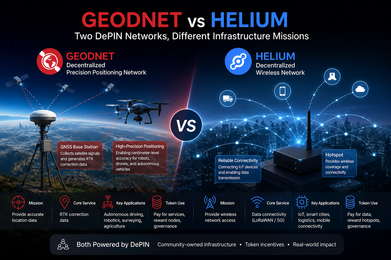
Within the DePIN ecosystem, Helium is typically seen as the flagship for decentralized wireless communication, while GEODNET stands out as a key example of a decentralized high-precision positioning network. Both rely on real hardware and real-world data services, but the industries they serve and their technical directions are completely different.
What Is GEODNET?
GEODNET is a DePIN network focused on high-precision positioning. It continuously collects satellite navigation signals through globally deployed GNSS reference stations and generates RTK correction data. When terminal devices receive these corrections, they can improve standard GNSS positioning from meter-level accuracy down to centimeter-level precision.
GEODNET's primary goal is to build a distributed global positioning infrastructure that provides high-precision location services for drones, autonomous driving systems, robots, and surveying equipment. Unlike traditional RTK networks, GEODNET expands its reference station network through community participation, allowing the infrastructure to grow in a more open manner.
What Is Helium?
Helium is a decentralized wireless communication network that allows global users to deploy hotspot devices and provide network coverage to nearby devices. Initially, Helium focused on IoT communication, using LoRaWAN technology to enable long-distance data transmission for low-power devices.
As the network scaled, Helium expanded into mobile communications and began building a more open wireless ecosystem. Its core goal is to use a community-driven approach to construct communication infrastructure, lowering the cost and barriers associated with traditional telecom network expansion.
What Is the Difference Between the Core Goals of GEODNET and Helium?
Both GEODNET and Helium are real-world infrastructure networks, but they solve fundamentally different problems. GEODNET aims to improve device positioning accuracy by providing high-quality location data that helps devices understand where they are. Helium aims to enhance device connectivity by providing wireless communication networks that enable devices to exchange data with external systems.
Functionally, GEODNET answers the question "where is the device?" while Helium answers "how does the device connect?" The former is spatial positioning infrastructure, the latter is communication infrastructure—each occupies a different layer in the digitalization of the physical world.
How Do the Data Services Provided by the Two Networks Differ?
GEODNET's core product is RTK correction data. GNSS reference stations continuously monitor satellite signal errors and generate positioning corrections sent to terminal devices. Drones, robots, or autonomous vehicles use this data to achieve positioning accuracy far beyond what standard GPS offers.
Helium provides communication services. Hotspot devices forward data traffic from terminal devices, allowing sensors, trackers, and mobile terminals to connect to the network. The network's value comes from coverage and communication capacity, not location data itself.
In short, GEODNET delivers high-precision positioning data, while Helium delivers network connectivity. These services address different fundamental needs across different levels.
What Hardware Devices Do GEODNET and Helium Use?
Hardware is one of the most visible differences between the two networks. GEODNET nodes typically consist of GNSS receivers, multi-frequency antennas, and reference station equipment. These devices continuously receive navigation signals from satellite systems such as GPS, BeiDou, and Galileo, and compute error corrections based on known coordinates.
Helium nodes center on wireless hotspot devices. These hotspots provide connectivity to nearby devices via wireless protocols, with the primary task of expanding communication coverage and increasing network capacity. Given their different service goals, the two types of devices differ significantly in deployment methods, operational logic, and maintenance requirements.
How Do the Two Networks Expand Their Infrastructure?
Both GEODNET and Helium use token incentives to drive network growth, but the logic behind that growth differs. GEODNET focuses on reference station density, because high-precision positioning requires enough reference stations for continuous coverage. As the number of stations increases, the network can provide more stable and accurate positioning.
Helium focuses more on communication coverage and network utilization. As the number of hotspots increases, the network can cover more areas and support more terminal devices. In other words, GEODNET's expansion goal is to improve positioning quality, while Helium's goal is to improve connectivity.
What Is the Difference Between the Token Economic Models of GEODNET and Helium?
While both use common DePIN incentive mechanisms, the sources of token demand differ significantly. GEODNET's token economy is built on demand for high-precision positioning services: enterprises and developers need RTK data, while node operators earn rewards by contributing positioning infrastructure.
Helium's economic system revolves around communication traffic. Network users consume communication resources to access services, while hotspot operators earn rewards based on coverage contribution and data transmission. Both token models stem from real-world demand—one serves the positioning market, the other the communication market.
Which Industries Do the Two Networks Serve?
GEODNET mainly serves autonomous driving, drones, smart agriculture, industrial robotics, and surveying. These scenarios demand high positioning accuracy, and centimeter-level precision often directly impacts device performance and automation levels.
Helium is more commonly used in IoT, logistics tracking, environmental monitoring, smart cities, and remote sensor networks. These industries focus on device connectivity and communication costs, making wireless coverage a core requirement.
From an industry perspective, while both are DePIN projects, their target users and market demands do not overlap.
Which Model Is More Suitable for the Physical AI Era?
Physical AI refers to AI systems that perceive and interact with the real world, such as autonomous vehicles, autonomous robots, and smart drones. These devices need both real-time connectivity and accurate location awareness.
From this angle, GEODNET and Helium are not direct competitors. GEODNET provides the location layer infrastructure, helping devices understand spatial coordinates. Helium provides the connectivity layer infrastructure, enabling data exchange. In the future, smart devices will likely depend on both positioning and communication networks, making these two models complementary rather than substitutive.
GEODNET vs Helium: Core Comparison
| Dimension |
GEODNET |
Helium |
| Infrastructure Type |
High-Precision Positioning Network |
Wireless Communication Network |
| Core Function |
RTK Positioning Correction |
Wireless Connectivity Service |
| Data Type |
Positioning Data |
Communication Data |
| Node Equipment |
GNSS Reference Station |
Hotspot |
| Target Users |
Drones, Robots, Autonomous Vehicles |
IoT Devices, Mobile Terminals |
| Value Source |
Positioning Service Demand |
Network Traffic Demand |
| Coverage Logic |
Reference Station Density |
Communication Coverage Range |
| Physical AI Relevance |
High |
Medium |
Conclusion
GEODNET and Helium are both key infrastructure projects in the DePIN space, but they solve different real-world problems at different layers. GEODNET focuses on high-precision positioning, providing centimeter-level navigation through a global GNSS reference station network. Helium focuses on wireless connectivity, building an open communication network via community-deployed hotspots.
From an industry positioning standpoint, GEODNET is closer to location infrastructure, while Helium is closer to connectivity infrastructure. As the robot economy, autonomous driving, and Physical AI continue to develop, both positioning and communication capabilities will become increasingly important. Looking ahead, these two networks are more likely to jointly form the underlying infrastructure needed for real-world intelligent systems—rather than compete directly.
FAQs
What Is the Biggest Difference Between GEODNET and Helium?
GEODNET provides high-precision positioning to give devices centimeter-level location data. Helium provides wireless communication to help devices connect to networks and transmit data.
Why Does GEODNET Need GNSS Reference Stations?
GEODNET uses GNSS reference stations to continuously monitor satellite signal errors and generate RTK correction data, enabling high-precision positioning for terminal devices.
Why Does Helium Need Hotspot Devices?
Helium hotspot devices provide wireless coverage and data forwarding, making them an essential part of the communication network.
Is There Competition Between GEODNET and Helium?
GEODNET and Helium serve different infrastructure layers—GEODNET is a location-layer network, Helium is a connectivity-layer network. They are more complementary than competitive.